29 nights onboard Sylvia Earle

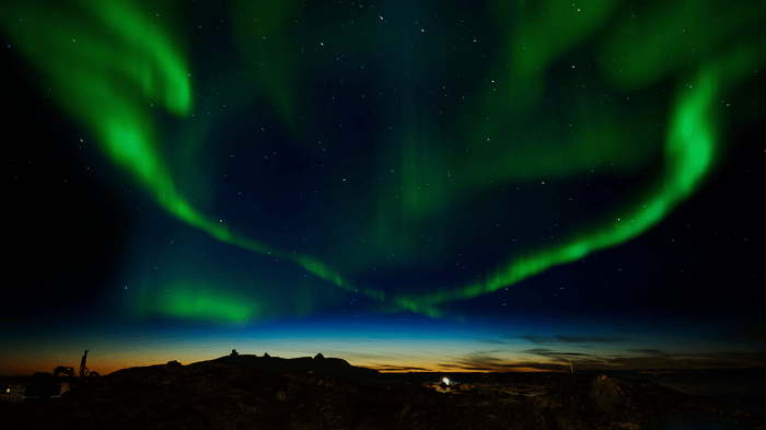
Complete Northwest Passage (Westbound)

Winners 2022 Best Expedition Cruise Line

On this epic voyage inspired by Roald Amundsen’s historic expedition, we attempt to sail the full length of the Northwest Passage, carving our way west through the labyrinthine maze of waterways that hug the fabled islands of Arctic Canada until we reach the Beaufort Sea. Building on our classic Northwest Passage voyage, we visit historical sites explored by heroic explorers, meet the incredible folk that call this region home, and search for enigmatic wildlife found in this unique corner of the world. Pack ice may halt our voyage through the passage, so brace yourself for a genuine expedition where adventure awaits at every turn.

Leaving from: Toronto, Ontario
Cruise ship: Sylvia Earle
Visiting: Toronto, Ontario Kangerlussuaq Havn Sisimiut (Holsteinsborg) Ilulissat (Jakobshavn)
AE Expeditions Logo
AE Expeditions

AE Expeditions is a small Australian cruise line which specialises in off-the-beaten-track voyages led by remote area experts.

The company’s adventurous co-founders, Greg and Margaret Mortimer, established AE Expeditions in 1991 and had by the following year, already begun running voyages to Antarctica

132
Passengers
74
Crew
2021
Launched
7400t
Tonnage
104.4m
Length
18.2m
Width
12kts
Speed
8
Decks
USD
Currency
Cruise Itinerary
Day 1
Toronto, Ontario, Canada
Day 2
Kangerlussuaq Havn, Greenland
Day 3
Sisimiut (Holsteinsborg), Greenland
Day 4
Ilulissat (Jakobshavn), Greenland
Day 5
Qeqertarsuaq (Godhavn), Greenland
Days 7 - 10
Baffin Island, Nunavut, Canada
Day 11
Devon Island, Nunavut, Canada
Day 12
Beechey Island, Nunavut, Canada
Days 18 - 22
Amundsen Gulf, Northwest Territories, Canada
Days 23 - 28
River travel
Day 29
Nome, Alaska, Alaska
Day 30
Anchorage, Alaska, Alaska
Toronto, Ontario, Canada image
Day 1
Toronto, Ontario, Canada
Kangerlussuaq Havn, Greenland image
Day 2
Kangerlussuaq Havn, Greenland
The name Kangerlussuaq means "Big Fjord" in the local Kalaallisut language. The settlement of about 500 people is located in western Greenland on flat land at the head of a fjord with the same name. Kangerlussuaq is the site of Greenland's largest commercial airport and most of the economy here is dependent on the air transportation hub and tourism. The rugged lands around the settlement support terrestrial Arctic fauna including muskoxen, caribou, and Gyrfalcons.
Sisimiut (Holsteinsborg), Greenland image
Day 3
Sisimiut (Holsteinsborg), Greenland
Located just north of the Arctic Circle, Sisimiut is the northernmost town in Greenland where the port remains free of ice in the winter. Yet it is also the southernmost town where there is enough snow and ice to drive a dogsled in winter and spring. In Sisimiut, travelling by sled has been the primary means of winter transportation for centuries. In fact, the area has been inhabited for approximately 4,500 years. Modern Sisimiut is the largest business center in the north of Greenland, and is one of the fastest growing Greenlandic cities. Commercial fishing is the lead economy in the town‘s thriving industrial base.
Ilulissat (Jakobshavn), Greenland image
Day 4
Ilulissat (Jakobshavn), Greenland
Known as the birthplace of icebergs, the Ilulissat Icefjord produces nearly 20 million tons of ice each day. In fact, the word Ilulissat means “icebergs” in the Kalaallisut language. The town of Ilulissat is known for its long periods of calm and settled weather, but the climate tends to be cold due to its proximity to the fjord. Approximately 4,500 people live in Ilulissat, the third-largest town in Greenland after Nuuk and Sisimiut. Some people here estimate that there are nearly as many sled dogs as human beings living in the town that also boasts a local history museum located in the former home of Greenlandic folk hero and famed polar explorer Knud Rasmussen.
Qeqertarsuaq (Godhavn), Greenland image
Day 5
Qeqertarsuaq (Godhavn), Greenland
Baffin Island, Nunavut, Canada image
Days 7 - 10
Baffin Island, Nunavut, Canada
Devon Island, Nunavut, Canada image
Day 11
Devon Island, Nunavut, Canada
Devon Island, located in Baffin Bay, is only slightly smaller than Croatia. The eastern side is frosted by the Devon Ice Cap, while on the western half of the island lays the 14 mile wide Haughton impact crater. It was created around 39 million years ago when a meteorite crashed into the land. The landscape surrounding this site resembles the surface of Mars. In fact, for the past decade scientists have conducted research here to determine how humans might live one day on Mars. British Arctic explorers Robert Bylot and William Baffin were the first Europeans to sight the island in 1616. In 1819-1820, William Parry charted the island, naming it North Devon after Devon in England. Despite repeated attempts at trading settlements, the strong wind conditions and cold climate eventually drove everyone away leaving Devon Island as a likely candidate for being the world’s largest uninhabited island.
Beechey Island, Nunavut, Canada image
Day 12
Beechey Island, Nunavut, Canada
Beechey Island is a small island off the southwest coast of Devon Island, separated by a narrow waterway called the Barrow Strait. Captain William Edward Parry was the first European to visit the island in 1819. His lieutenant, Frederick William Beechey, named the island after his father, the artist William Beechey (1753–1839). Beechey Island played a significant role in the history of Arctic Exploration. During the winter of 1845-46, Sir John Franklin and his men camped on the island as part of their ill-fated quest to find the Northwest Passage. Mummified remains of three of Franklin’s crew were discovered, giving a better understanding of what happened before the disappearance of the expedition. In 1850 Edward Belcher used the island as a base while surveying the area. Later, in 1903, Norwegian explorer Roald Amundsen stopped at the island at the beginning of his successful voyage in search for the Northwest Passage. Subsequently, Beechey Island has been declared a "Territorial Historic Site" since 1975 by the Northwest Territories government
Amundsen Gulf, Northwest Territories, Canada image
Days 18 - 22
Amundsen Gulf, Northwest Territories, Canada
River travel image
Days 23 - 28
River travel
Nome, Alaska, Alaska image
Day 29
Nome, Alaska, Alaska
Nome is located on the edge of the Bering Sea, on the southwest side of the Seward Peninsula. Unlike other towns which are named for explorers, heroes or politicians, Nome was named as a result of a 50 year-old spelling error. In the 1850's an officer on a British ship off the coast of Alaska noted on a manuscript map that a nearby prominent point was not identified. He wrote "? Name" next to the point. When the map was recopied, another draftsman thought that the “?” was a C and that the “a” in "Name" was an o, and thus a map-maker in the British Admiralty christened "Cape Nome." The area has an amazing history dating back 10,000 years of Inupiaq Eskimo use for subsistence living. Modern history started in 1898 when "Three Lucky Swedes”, Jafet Lindberg, Erik Lindblom and John Brynteson, discovered gold in Anvil Creek…the rush was on! In 1899 the population of Nome swelled from a handful to 28,000. Today the population is just over 3,500. Much of Nome's gold rush architecture remains.
Anchorage, Alaska, Alaska image
Day 30
Anchorage, Alaska, Alaska
Anchorage is the largest city in Alaska. Located between mountains, it is a beautiful mixture of urban and wilderness. Thanks to its proximity to the Chugach State Park with its 45 species of mammals and the city's rich history, there is so much to be seen in this unique destination.
Ship Details
AE Expeditions
Sylvia Earle

Introducing our new ship, the Sylvia Earle

A floating ambassador for the planet

Find your perfect cruise!
Cabins
All Prices